
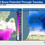
A wintry mix of snow, sleet and freezing rain is likely through Tuesday. There could be some accumulations of ice tonight into Tuesday morning, mainly south of I-96. A midweek warmup is anticipated with precipitation changing to all rain by Wednesday.
Issued By
Grand Rapids – MI, US, National Weather Service
Affected Area
Portions of south central and southwest Michigan
Description
…WINTER WEATHER ADVISORY NOW IN EFFECT UNTIL 4 PM EST TUESDAY… WHAT…Mixed precipitation. Additional snow accumulations of up to one inch and ice accumulations of one tenth to two tenths of an inch. WHERE…Portions of south central and southwest Michigan. WHEN…Until 4 PM EST Tuesday. IMPACTS…Plan on slippery road conditions. The hazardous conditions could impact the morning or evening commute. ADDITIONAL DETAILS…Precipitation will likely change between snow, sleet, and freezing drizzle at times this afternoon. A brief lull in precipitation is possible late this afternoon before widespread wintry precipitation arrives this evening. PRECAUTIONARY/PREPAREDNESS ACTIONS… Slow down and use caution while traveling.